Climatic Limits Of The Boreal Forest
5.2.1 Relating distribution to temperature
Throughout North America and Eurasia trees reach a northern distribution limit, which can be compared with a number of thermal indicators. However, this does not mean that in all these areas the same natural processes are limiting the northern extension of boreal forests. Traditionally, the northern boundary of the boreal forest (the tundra-taiga interface) has tended to be considered as a purely thermal phenomenon. In North America this has been related to the median July position of the polar front which matches approximately the 10 °C July isotherm (Bryson, 1966). Koppen's Rule, a long-established rule of thumb often used to relate climatic tolerance to temperature in North America and Europe, states that trees do not survive when the mean temperature of the warmest month fails to rise above 10 °C (Koppen, 1931).
A more accurate correlation can be obtained by using measurements that reflect the mean temperature of the entire growing season as detected in meansoil temperatures. A worldwide study of high-altitude tree-line temperatures found that, disregarding taxa, land use, or fire-driven tree limits, high-altitude climatic treelines can be associated with a seasonal mean ground temperature of 6.7 °C ± 0.8 SD, and a 2.2 K amplitude of means for different climatic zones, which is a surprisingly narrow range. Temperatures were higher (7-8 °C) in the temperate and Mediterranean zone treelines, and are lower in equatorial treelines and in the subarctic andboreal zone(Korner & Paulsen, 2004). In all cases this is significantly lower than the 10 °C isotherm that was the basis of Koppen's Rule. However, in any discussion between cause and effect it is necessary to remember that mean temperatures, either of warmest months or entire growing seasons, do not exist in nature and therefore should be considered only as indicators and not causal factors (Holtmeier, 2003).
Despite attempts to find a common causal basis for the position of thearctic treeline(see Table 5.1) in North America and Europe, a generalized solution has proved elusive. This is not surprising given that tree-lines are frequently only approximate limits to the altitudinal or latitudinal distribution of scattered but upright trees (Sveinbjornsson, 2000). The degree of scatter can vary, and inparts of Russiathe development of a mosaic of vegetation at the tundra-taiga interface is particularly noticeable.
The difficulty that forest ecologists have in agreeing on the position of the arctic treeline can be seen in satellite images for North America and Siberia recording the distribution ofevergreen vegetationby using the Normalized DifferenceVegetation Index(NDVI) as seen in May 1998 (Figs. 5.5-5.6).
The NDVI is a simple, unitless index calculated from satellite-measured reflectance in the red and near-infrared regions oftheelectromagnetic spectrum(Tucker, 1979). The basis for the NDVI index is the strong reflectance of healthy green-leafed vegetation in the infrared region and strong absorption in the red region. The values range between values of —1 and + 1, in the sense that it is mathematically impossible
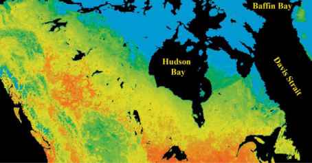
Fig. 5.5 Northern limits to the North American boreal forest: Normalized Difference Vegetation Index (NDVI) image recorded in May 1998 (8 km resolution). Colour scale: blue — 0; dark-green — 0.48—0.64; yellow-orange — 0.76—0.88. (Image prepared from 8 km resolution Pathfinder data set — US Geological Survey, EROS Data Center, Sioux Falls, South Dakota.)
Fig. 5.5 Northern limits to the North American boreal forest: Normalized Difference Vegetation Index (NDVI) image recorded in May 1998 (8 km resolution). Colour scale: blue — 0; dark-green — 0.48—0.64; yellow-orange — 0.76—0.88. (Image prepared from 8 km resolution Pathfinder data set — US Geological Survey, EROS Data Center, Sioux Falls, South Dakota.)
to have a value outside this range. Normally there is a strong correlation between the leaf area index (LAI) and the NDVI. But this does not imply that when the green LAI is zero the NDVI must also be zero.Snow and icegive NDVI values close to zero, while water bodies can give negative values. In the 8 km resolution images recorded in May 1998 (Figs. 5.5-5.6) there is a clear discontinuity between the blue area (NDVI = 0) which represents the tundra still covered in snow and ice, while the already photosynthetically active evergreen forest with the trees emerging through the snow is shown in dark and bright green (NDVI > 0.25).
In North America a southern displacement of the evergreen coniferous forest can be observed in easternoceanic regions, which are mainly east and west of the
Hudson Bay as well as in Labrador and Quebec (Fig. 5.5). Similarly in Eurasia, the West Siberian Lowlands show a marked southward displacement of the boreal forest between the rivers Ob' and Lena due to the influence of the Arctic Ocean (Fig. 5.6).
归一化植被指数图像也说明了智慧的怀疑h which many Russian ecologists view the concept of a boreal forest treeline and the possibility of mapping a treeline with any degree of precision (Kriuchkov, 1971). As shown in Fig. 5.4 the northern limit for boreal forest proper generally lies to the south of the northern limit for individual stands of trees. This extensive transition zone (forest ecotone) between intact forest and completely treeless tundra is particularly noticeable in the West Siberian Lowlands. A high resolution NDVI image from this transition zone
Novaya Zemtya
Continue reading here:Climatic Change And Forest Migration
Was this article helpful?
Readers' Questions
-
SHARON CARTER3 months ago
- Reply
-
Futsum1 year ago
- Reply